
Android geolocation function: outdoor and indoor possibilities
We explain the different methods available for locating packages, parcels, vehicles, stock items and employees, both indoors and outdoors, and what services can be expected from such systems, which we can code into customized barcode field data collection applications. This gives our customers a competitive edge and enables them to offer other services to their customers.
We customize these functions for your mobile traceability applications.
Geolocation principles and combinations of several technologies
Geolocation is based on several principles:
- the terminal to be located outdoors must be equipped with a device that can calculate its GPS position (i.e. in relation to suitable satellites) to obtain its geographical position on Earth, with a relative accuracy of around 10 to 20 meters.
- the terminal can also take the GPS position of the Wifi connection (if the Wifi sensor is also activated) when indoors: we then have the GPS position of the building it has entered, but we do NOT have its position inside the building. Wifi antennae and the 3 or 4G network can be used to calculate GPS position more quickly, thanks to the known position of their connections, and provided the device is equipped with these sensors and has access to them (authorization, SIM card, etc.): this is called “A-GPS” (Advanced GPS).
- the position of an IoT_: only IF we have access to the position of this IoT (whose code is read) by a server (like SigFox): we have the position of the terminal: complex to implement.
- An “IoT” can be placed on or in the product to be tracked: its position is retrieved via the Internet on the mobile.
- the relative position indoors in relation to a network of tags_ (Beacons) BLE (Bluetooth Low Energy) fixed (to walls, shelves, a building element): they act as “beacons”: we need to know the position of the Beacons in the building on a plan, the room or external storage surface so that the coordinates of the terminal in the building or external storage surface can be calculated by triangulation.
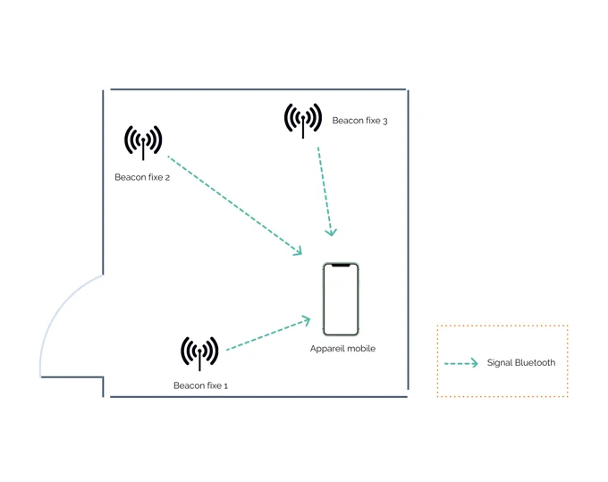
Principle of positioning a terminal relative to beacons in a given area (indoor or outdoor)
Consequences for geolocation
- the terminal / smartphone must be able to receive satellite positions, so its GPS antenna must be outdoors for a terrestrial position;
- the terminal must be BT BLE compatible to detect Beacons and have an internal program that calculates and displays a map of the location in question.
- the calculation device must be autonomous, or at least autonomous for a certain period of time: in other words, it must have a power source, such as a battery, which is what a terminal and Beacons have.
What we don’t do with geolocation
We’re frequently asked to geolocate with Rfid chips: apart from in a room equipped with Rfid readers, or walking around with an Rfid reader and a ‘Geiger’-type reading application, it’s impossible to locate things or people equipped with passive (classic) Rfid chips outdoors. In fact, Rfid chips do not comply with any of the above principles.
Barcode field data collection application
We had “on the shelf” a compiled application (.apk) for Android that shows:
- if your Android terminal is equipped with the right devices for geolocation, if it is properly set up for this,
- a GPS position is obtained: when the coordinates are displayed (longitude / latitude in decimal and deg min, sec ),
- imagine that these are sent to a server with the date, time, your login, etc… here they are associated with the parcel survey code.
Test application
We had made a compiled application (.apk) for Android which shows several things:
st part: if your Android terminal is equipped with the right devices for geolocation, if it’s set up properly for this,
- how to obtain a GPS position: when displaying coordinates (longitude / latitude in decimal and deg min, sec + altitude ), imagine that these are sent to a server with the date, time, your login, etc…
nd part :
what you can do with GPS coordinates on a map (OSM: OpenStreetMap, Google Maps): we exported the coordinates of the dropped parcel as a csv file, or through our favorite no-code interface with your databases as option.
Other retrievable data
In addition to the classic data (longitude/latitude), a GPS can also provide :
- altitude (useful for mountain terrain applications),
- terminal speed.
Offer new “field” services to your customers and employees, such as
- collect a package at the last minute from a vehicle in the customer’s vicinity,
- inform customers of the position of their equipment,
- Monitor your field teams,
- record fire hydrant maintenance,
- record roadwork, install signs,
- record interventions on electricity poles or telephone cabinets,
- Analyze your fleet activity,
- Control your costs,
- Increase the productivity of your fleet: possibility of last-minute pick-ups by a nearby vehicle: imagine receiving an order with a map showing the last positions of your objects/vehicles and those of your customer: choose the nearest vehicle and immediately send them the new mission via 4G on their application!